| ||||||||||
Amost two thousand years ago Roman engineers masterminded a road cut in the cliffs of the right bank of the Danube. Here it passes between the Carpathian and Balkan mountains in a series of gorges known as the Cazans [Kazan] or sometimes collectively as the Iron Gates.These gorges begin about 960 kms upriver from the mouth. Cazan is variously translated as ' cauldron, boiler or kettle' and any one of these describes water swirling in eddies pushed around by the relentless current. But no more. In 1972 the water rose thirtyfive metres behind the joint Yugoslavian-Romanian Iron Gate l dam and covered this outstanding achievement of ancient engineering. Now the gorges are filled with an uncannily peaceful lake. The Cauldron bubbles no more. | ||||||||||
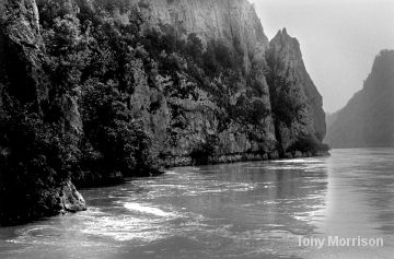 |  | |||||||||
Tony Morrison writes These pictures come from from my journey upriver in 1966 with John Marriner on his motor yacht September Tide. ' The spectacular gorges began about 7 kms above Orsova and continued for almost 50 kms. The Small Cazan came first, then the Great Cazan and finally the Golubac ' Those gorges have not changed and have become part of two National Parks, On the Serbian side it is the Derdap NP and on the Romanian side - the Portile de Fier [Iron Gates]NP. Before the rising water changed the width the narrowest part of the river was 150 m and the highest cliffs were 500 metres. The road built by the Romans followed the Yugoslav side , now the Serbian side giving a supply route into what was then known as Dacia - very roughly Romania today, where the Emperor Trajan was fighting a war. The Roman engineers plotted the route and the construction can be seen in these pictures | ||||||||||
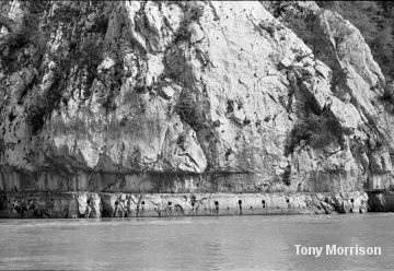 | 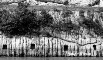 | |||||||||
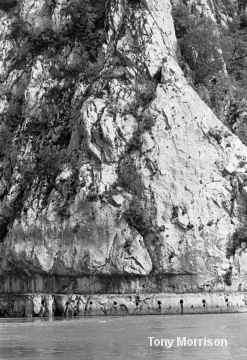
| To increase the width of the road a wooden extension built built over the river and supported by tressles slotted into holes cut just blow the road level - you can see the road near the top of the right-hand picture. This extraordinary work continued for about 9 kms soon after Orsova as well as and in other places were the cliffs were sheer | ||||||||||
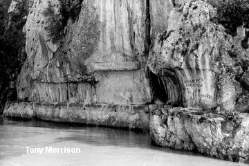 | 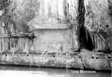 | |||||||||
Close to the Orsova end of the road a memorial plaque 4 m wide and 1.5 m high was carved in the rock. The carving was beside road and over the centuries much of the detail was erased. A decoration of eagles, dolphins and goddesses was just discernable in 1966. Three lines and part of a fourth line of the inscription were left and before the water rose the entire Tabula Traiana was cut from the cliff and lifted to a new, higher position.. These pictures show the Tabula in its original place | ||||||||||
Trajan's
Tablet also known as Tabula Traiana | ||||||||||
Here
is the Tablet / Tabula in its original position before the gorge was flooded | ||||||||||
| Touch the picture to see a closer view | ||||||||||
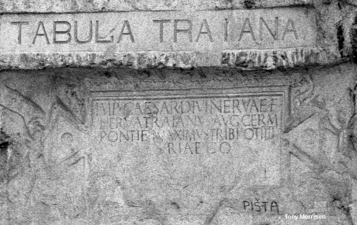 | ||||||||||
| IMP(ERATOR) CAESAR DIVI NERVAE F(ILIUS) | EMPEROR CAESAR SON OF THE DIVINE NERVA | |||||||||
| NERVA TRAIANVS AVG(USTUS) GERM (ANICUS) | NERVA TRAJAN AUGUSTUS GERMANICUS | |||||||||
| PONTIF (EX) MAXIMUS TRIB (UNICIA) POT(ESTATE) IIII | GRAND PONTIFF TRIBUNE FOR FOURTH TIME | |||||||||
| PATER PATRIAE CO (N)S(UL) III | FATHER OF THIS COUNTRY AND CONSUL FOR THE THIRD TIME | |||||||||
| MONTIBVUS EXCISI[S] ANCO[NI]BVS | TAMED THE MOUNTAIN AND THE RIVER | |||||||||
| SVBLAT[I]S VIA[M ] [R]E[FE]CIT | AND OPENED THIS ROAD | |||||||||
| The first lines are clear and the last three have been gleaned from historical references. The translation into English seems to depend on the author. But it is clear from history that Trajan gets the credit for something he finished but did not begin. | ||||||||||
|
Our journey upstream
through the Cazan gorges | ||||||||||
 | 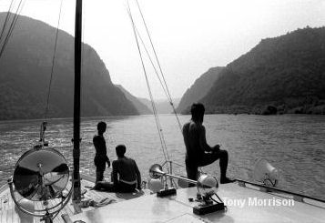 | |||||||||
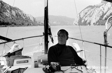
| September Tide in September 1966 - The gorges were spectacular and John Marriner said it was 'the finest river scenery hea had seen in the whole of Europe' In places the river was narrow and then between the sections constricted by grey cliffs it opened. We followed the road upsteam. | ||||||||||
 | 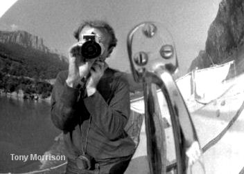 | |||||||||
| I used September Tide's large chrome plated spotlight as a mirror for a self portrait sheer cliffs rising 500 meters behind. | ||||||||||
 |  | |||||||||
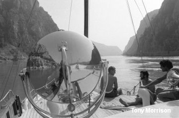
Alexandre Damaschin from Orsova who had joined us in Turnu Severin [see the Iron Gates page] was our River Pilot for the journey. Pilots were obligatory on this section of the river and Alexander took charge leaving John to relax with is camera and enjoy the scenery...... if it's possible for a working yachtsman to 'enjoy' scenery. | ||||||||||
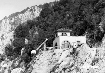 |  | |||||||||
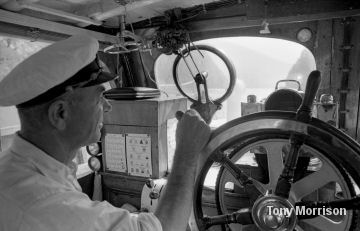
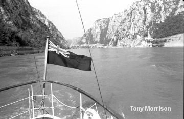
| We had to keep to a channel defined by anchored floating logs and our passage was controlled by signal stations perched on promontories. With the ball down we could proceed andl luckily there was little traffic. A tug the Bratislava passed going downstream. The Roman road is still in the picture - it's that horizontal line close to the water. We left the Cazans with the Blue Ensign flying proudly astern but we had one more tow ahead | ||||||||||
 | 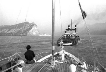 | |||||||||
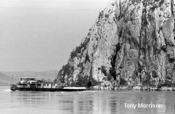
The final obstacle along this stretch was the current at Cape Greben [km 999] where Alexander promised us it would be running at about 18kms per hour. To pass this point most ships required help and were hitched to a special tug, the Vaskapu operated by a joint Yugoslav-Romanian river authority. The Vaskapu was a very unusual tug and it worked a distance of about two kilometers fixed to an underwater cable. September Tide was hitched to the Vaskapu and the tug powered by steam from wood-burning then hauled itself along the cable. With the new lake behind the dam reaching well beyond this point the current has gone and so has the Vaskapu. But for us, we had another 18 kms of spectacular scenery By Cape Greben we met a brand new Austrian passenger ship the Freidrich Korner - you can see the white vessel near the Cape and the passengers being given a warm-up for the river experience of a lifetime. We waved and they must have been surprised to see our tiny September Tide - just 17 m long [55 feet] emerging from the spectacular and daunting 'Country of the Cauldrons' | ||||||||||
| ||||||||||