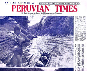
| By Mark Howell One
of the most difficult questions to answer, about the journey Tony Morrison and
I made down the Vilcanota and Urubamba rivers * — from Urcos to Atalaya is
why we did it. "Well " one starts, " It was like this..."
And then one tends to find oneself at a loss for any succinct and satisfactory
way of going on. Broadly, it was an attempt to find out whether it was possible
to travel by boat from a source of the Amazon down to one of the generally accepted
upper limits of navigation, and if so to film the descent. Another dubious distinction
we could claim, would be that we were the first people to navigate the Pongo
de Mainique in a rubber boat. Probably one of the best reasons, though is
curiosity; to visit the almost unknown areas of the valley below the Pongo is
possible only by river. *
See the Peruvian Times of Feb.22, 1963 for reference to other descents of the
Urubamba. The Urubamba above Machu Picchu is generally referred to as the Vilcanota
although there is no general agreement as to where the river changes its name.
[Peruvian Times editor] Mark,
Tony John [Johannes] and Hugo returned to Quillabamba after a two week walk in
the Vilcabamba range to cover a story about a Lost Inca City. Last
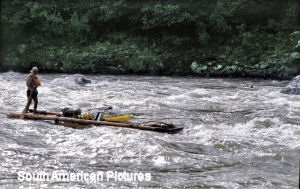
Stage on the Urubamba Our return journey took four days and 2 weeks
after we had set out from Quillabamba we were embarking on the last and, reputedly,
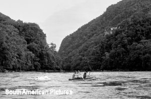
the most dangerous stage of our descent of the Urubamba. We had bought a balsa
raft, to be captained by Hugo from which Tony could film the progress of the dinghy
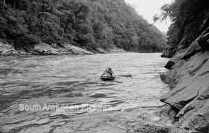
in close-up. Whirlpools
Although
the river appeared to have changed only in size, closer acquaintance made possible
by a rubber boat, showed more disturbing charactersistics. The whirlpools previously
small enough to 'skate' over , were now large enough to hold us for minutes on
end. They were only avoidable by staying in the main current on the bends where
five and six foot waves converged from all directions and permanent spray threatened
to fill the boat. At first we were fairly complacent — "well with all
this air in the boat we can't sink" — an opinion we modified when we
discovered before long that two violently converging currents could surge over
our one foot freeboard, and float off with our film in less time than it takes
to tell. Sometimes it was possible, by paddling frantically, to avoid an obstacle
spotted two hundred yards downstream, but more often it was only possible to utter
a heartfelt prayer and emerge from a welter of six foot waves resolving to stop
this idiocy immediately. Whereas higher up almost every rock or obstruction seemed
to have protective cushions of water around it, below Quillabamba it was not unusual
to see the main current dive below an undercut cliff and emerge from the depths
in a boiling upsurge many yards downstream. In the course of two days our paddling
muscles developed impressively; and our general tacit consensus of opinion, that
this was a river to treat with immense respect. Unnerving recollections of the
number of unfortunates this river had drowned returned to distract us from time
to time. Seven
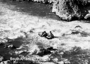
Great Rapids The
final descent of the Urubamba to the Pongo de Mainique is through a series of
seven great rapids, like the treads of a stairway. The balsa raft went through
the first with Hugo expertly threading between the spray shrouded rock. It seemed
to us in the rear boat to be moving at a frightening speed. Tony standing on the
front and holding the movie camera above his head, was submerged to his chest
with every wave. Then it was our turn. We swept through the first rapid shipping
only a few gallons, and shaped up for the second. It was not until we were twenty
yards from it that we realised the significance of a high standing wave blocking
half the width of the river. A huge boulder the top of which was perhaps four
or five feet below the surface was causing a build-up of water— we had seen
several much smaller ones upsteam. The danger was not in the wave but the great
hole in the water behind the rock, which was four or five times as deep as the
height of the wave. We paddled as we had never had before, but it was hopeless.
As we swept up to the crest of the wave I had a momentary glimpse of a hole eight
or nine feet deep and then the boat was tossed high into the air and we were ejected
from it like stones from a catapult. Survival
Afterwards
Hugo told us that the longest a strong swimmer can expect to survive in one of
these rapids is about two minutes. As John and I were wearing jackets, trousers
and shoes it was a miracle we lasted that long. Somehow John managed to grasp
one of the dinghy's life lines, but I was swept away from it and had I not managed
to seize a piece of basla wood which had been thrown out of the dinghy with us,
I should have drowned in the rapid. As it was I was too exhausted by the violence
of the water to be able to swim with any power when I was into the calm but swift
section 200 yards downstream. Fortunately, Hugo was able to manouevre the balsa
close enough to me to dive in wearing a life jacket, and drag me into the bank.
We reached it only ten yards above the next rapid which would have drowned both
of us. Half
an hour later when I had recovered enough strength to walk, we found the others
some 500 yards downsteam where John had managed to beach the dinghy with an oar
he found jammed underneath it. Most of our valuable equipment had been tied into
the boat, the cameras and film had been wrapped in plastic sheeting and had not
suffered, but our tape recorder, a pair of shoes and a jacket had been washed
away. However the gratifying thing was that neither John nor I had been. The
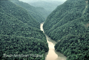
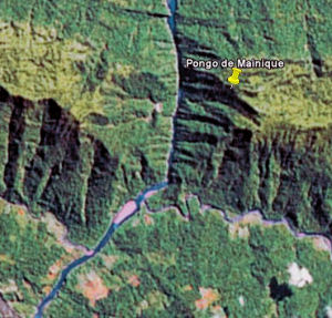
Pongo de Mainique In
an hour we were ready to continue. My own attitude was one of complete resignation;
having barely escaped drowning, and still completely exhausted, I should perhaps
have resisted the suggestion to continue, at least for a while. But when, ten
minutes later I saw the mouth of the Pongo come in sight I summoned a surprising
amount of energy for evasive paddling. The water boiled and disappeared into a
high, dark, forbidding cut in the hills; I recall a vague impression of a confused
white water slope and then we were slipping along on an absolutely calm surface,
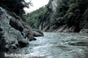
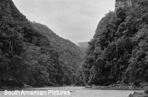
very fast between high grey walls; we had entered the Pongo of awful repute. This
was the climax of our whole expedition; the Pongo had never been filmed and only
rarely and inadequately photographed. Usually, merely passing through it had been
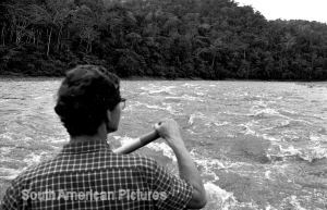
reckoned an adequate enough achievement. While keeping a wary ear cocked for the
sound of breaking water downstream, Tony filmed the dinghy gliding past the sheer
grey cliffs iof the canyon. Waterfalls cascaded down in graceful veils. Halfway
through the Pongo, we had been warned, was a dangerous rapid with two whirlpools,
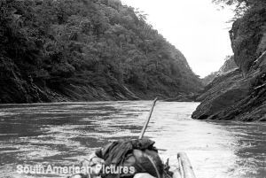
but we bounced through this hardly shipping a drop. The walls on either side of
us climbed higher, probably 600 or 700 feet, and the sky diminished to a narrow
strip. Dense, damp, vegetation covered the upper levels of the cliffs, absorbing
all sound except the incessant drip of water. Twenty
minutes after entering it, we passed through the jaws of the Pongo, two high cliffs
jutting into the river, narrowing the gap by more than half. Hugo pointed up and
said " 'Once there was an Inca bridge across there ". John and
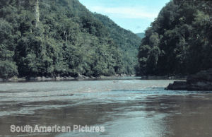
I shouted our disbelief and he shrugged his shoulders eloquently. Then within
minutes the river was ten times as wide, slow and widing. We paddled unhurriedly
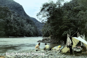
across to a long low playa [beach] which would serve for our first night's
camp on this new languid river, glad that we had survived but sorry too, in a
way that for the next 200 miles would be just a leisurely unwinding lowland river. A
piece of advice I feel bound to give to anyone wanting to navigate the lower Urubamba,
is that to attempt it without a guide would be suicidally dangerous. Although
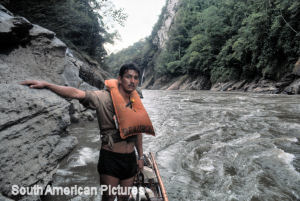
we were unable to obtain any Machiguenga guides, Hugo had been through the Pongo
several times, although not on a balsa, and he was an experienced riverman. Had
it not been for him one of us at least would probably have drowned. And the already
impresssive score of fatalities the Pongo already has to its credit shows that
our experience was nothing out of the ordinary. The
Boat used by the Urubamba expedition was a 9-foot Avon Redcrest
manufactured in various sizes by the Avon Rubber Co, Melksham, Wiltshire, England.
[now Avon plc] Hugo Echegueray the guide on the Urubamba expedition was so impressed
by the handling and other charachteristics in the dangerous conditions of the
Urubamba that he is planning to set up an agency for importing the craft. Publisher's
note referring to Howell's book ' Journey Through a Forgotten Empire'
" They saw the 'Lines of Nazca', the gigantic calculations astronomers
drew on the featureless desert thousand of years ago; they spent some days on
the feudal estate of the millionaire Suares; they had the amazing luck to find
the unique Chipaya community, poignant living remnant of pre-Inca time two days
before 'civilisation' in the shape of dried milk and electricity arrived by courtesy
of US AID; and finally in San Antonio de Lipes, a high Andes ghost town, they
stumbled upon the crumbling remains of a vast and richly appointed cathedral." Now
to bring the story up-to date... - 1967
' Steps to a Fortune' a book by Mark Howell and Tony Morrison,
Geoffrey Bles, London. It includes an account of a meeting with Fidel Pereira
the patriarch of the lower Urubamba and an account of the journey through the
Pongo.
- This
region of the eastern Andes is noted for its great bio-diversity It is a meeting
place of species from the slopes of the mountains and Amazon lowlands. Also their
is a movement of species both plant and animal north and south using the mountains
as a pathway. The Pongo like a gateway offers free movement especially for birds
and insects.
- Over
the past fifty years the road down the valley from Quillabamba has been extended
- bit by bit more or less as settlements have required. In the 1960's only the
remnant of an old trail led to the Pongo and beyond. The trail was made at the
end of the 19th century when this area was part of a much larger 'Rubber Empire'
where natural rubber was collected and exported via the Amazon river.
- In
the 1980's Tony has returned a couple of times by air overflights and to the even
more remote Isthmus of Fitzcarrald while following the story of Lizzie Hessel
an English woman who travelled to rivers just below the Pongo with her husband
in 1896. They were employees of Carlos Fermin Fitzcarrald an entrepeneur intent
on making a fortune in the Rubber Boom / Lizzie- The Amazon Adventures of a
Victorian Lady, Tony Morrison, Ann Brown and Anne Rose, BBC Books 1985
- In
recent years the lower Urubamba - above and through the Pongo has become a whitewater
rafting destination.
- The
Pongo has featured in several films, notably in 'Fitcarraldo' 1982 written and
directed by Werner Hertzog; A BBC travel series Full Circle' 1997 with Monty Python
actor, Michael Palin; and documentaries.
- Modern
accounts often say say an Inca bridge exists across the Pongo - they must be incorrect
as the bridge was was not there in 1964. If it's there now it's certainly not
Inca.
Early
accounts 1916
The Andes of Southern Peru Isaiah Bowman / American Geographical Society /
Henry Holt and Company, New York. Yale Peruvian Expedition 1911, Hiram Bingham,
credited with discovering Machu Picchu was Director of the expedition. 1932
West Coast Leader [Predecessor of the Peruvian Times] July 26th 1932, A report
of the death of Professor J. W Gregory. 1953
Rafting the Urubamba Malcolm K. Burke a series of eight stories in the Peruvian
Times, Lima, February 3rd / March 19th 1956 - Malcolm Burke was a writer based
in Lima and he made raft journeys down the main Amazon tributaries. All reported
in the Peruvian Times. 1958
Quest for Paititi, Julian Tennant, Max Parrish , London [1954] 1961
The Cloud Forest, Peter Matthiessen, Viking, New York And
there may be others before 1964 - if so please send an e-mail to the editor -
see CONTACT INFO To
return to the top of this page
|
|
| The
text and most of the images are © Copyright |
| For
any commercial use please contact | | |
| THE
NONESUCH - FLOWER OF BRISTOL |
| AN
EMBLEM FOR ENTERPRISE | | |