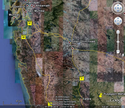
| Pusegaon
the centre for the team's studies is about 40 kms east of Satara [near
the bottom of the first map / right] Satara is the principal town of the area
and served by the main road and railway system leading south from Pune.
Because of its good
communications Satara was the hub for the project. Touch the map for a closer
look. Koregaon
a small town which in the 1960's had an iron-works producing agricultural machinery
is 18 kms east of Satara and Aundh once the capital of a small Princely
State is 26 kms southeast of Satara. The team visited the schools, industrial
works, cultural and religious centres of all three. Pusegaon
17° 43´ 00 N / 74° 49´ 60 E Altitude 2670 feet / 813m on the
Deccan - on the southwestern side of India. Population in 1960 approx 2500 Population
in 2000 approx 9000 and over 30,000 in the surrounding area |